|
|---|
 |
 |
 |
 |
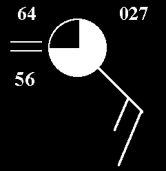
Decoding Surface Observations
When you "click" on the button to the left that says "Image" it will show a map of the southern United States.
Station reports are shown at locations across the states. If you are not familiar with the particular numbers or symbols contained in the reports, just "click" on the item in question in the diagram below and information will be provided.